Hanford Reach

What is Hanford Reach?

The Hanford Reach is a free-flowing section of the Columbia River (around 51 miles long), in eastern Washington. Upstream is Priest Rapids Dam and downstream is the McNary Dam.

It is named after a large northward bend in the river’s southbound course. Did you know that the Columbia River actually starts in Canada?

Since 1943 the area has been untouched by development or agriculture and is now considered an involuntary park. Human habitation/use has been stopped. Don’t come expecting a lot of visitor facilities—they don’t exist. You’ll be experiencing the Monument on its own terms.

Hanford Reach
Chinook Salmon

Ancestral Land
For thousands of years, people have depended on the Hanford Reach of the Columbia River—”Chiawana” (Big River)—and its tributaries to survive in the desert environs of the Columbia Basin. As early as 10,000 years ago, the ancestral inhabitants of today’s Wanapum People, Yakama Nation, Confederated Tribes of the Colville, Confederated Tribes of the Umatilla Reservation, and the Nez Perce fished, hunted, and collected a variety of natural resources in the area.

The abundant salmon were complimented by upland roots, seeds, and game. Seasonal gathering of resources such as spring roots or fall Chinook salmon required moving ‘camps’ often. Tule (bulrush) mats were draped over willow poles for temporary shelter. In winter, shallow oval pits were dug and poles covered with tule, willow, or hides for more permanent ‘housepit’ villages along the Reach. Even today, Native Americans gather the tules for making house coverings, sleeping mats, and other household uses.

Native American traditional use areas and aboriginal occupation areas were destroyed before and during the establishment and operation of the Hanford Nuclear Reservation. Protection of these cultural resources—including tangible portions of sites such as artifacts, features, structures, natural resources, and landscapes (e.g., traditional use and sacred areas), as well as oral and written records—is paramount to the management of the Monument now.

Early Settlements
The Columbia River was a driving force for development. From the time the first explorers passed through the area, the river was the logical transportation corridor and remained the avenue to transport goods and people for nearly a century until the railroads arrived. Water for crops was critical, so irrigation companies formed. The development of several irrigation and land companies, supported in part by outside capital, led to the true settlement and townsites development.

The anticipation of profits provided incentives for Seattle-area developers to invest in the area. The success of the venture brought the first significant regional recognition to this unknown area, based primarily on the area’s mild climate, readily available and level land, perfect growing conditions for early crops, and irrigation. Orchards replaced other crops and livestock as a profitable commodity. The marketing of the new real estate and fruit crops resulted in railroad connections by 1913 with a spur line to Hanford from the Chicago, Milwaukee, and St. Paul Railroad, which provided the link for shipping products to coastal markets. The rail lines also benefited farmers through quicker receipt of supplies and equipment. Ironically, the rail lines resulting from irrigation changed the Columbia River’s role as a transportation corridor; by the 1920s, steam freighters had nearly vanished from the river.

For over two decades, the towns of Hanford and White Bluffs grew and prospered. The White Bluffs area was selected as a soldiers’ home location after WWI; many of these ex-soldiers provided labor to established farmers. Advertisement through the realty companies and railroad land agents attracted nearly 500 families, many fleeing the Midwest in the 1920s and 30s looking for new starts. The Depression years reduced prosperity as a result of lower crop values, but many families could at least continue their own existence through subsistence farming and local economic systems. The First National Bank of White Bluffs remained open, and presumably solvent, throughout the lean years, not closing until 1942.

In 1943, the War Department (later the Department of Defense) went in search of a remote, sparsely populated, easily defensible, geologically stable site with plenty of cool water, abundant energy (from hydropower dams on the Columbia River), and a moderate climate in order to build plutonium production reactors in secret. The United States Army Corps of Engineers selected a site near the isolated desert towns of White Bluffs and Hanford. Following site selection, the War Department acquired land through the condemnation of private lands and the purchase of any private lands within the basin formed by Rattlesnake Mountain and the Saddle Mountains. The Atomic Energy Commission, a precursor to the Department of Energy (DOE), then established and ran the Hanford Site (then known as the Hanford Engineering Works).

The Manhattan Project, designed to build the atomic bombs of WWII, required the removal of all residents of White Bluffs and Hanford. Although some of the buildings became offices and residences for a short time, most were eventually removed along with crops, orchards, and landscaping. At its essence, the “progress” of the atomic age helped to turn the landscape back in time, at least on the borderlands that make up the Monument.

Hanford B-Reactor

Hanford Site
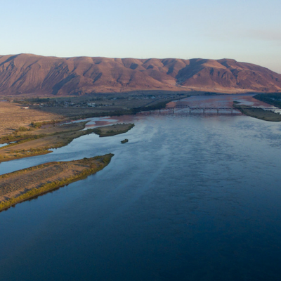
The Hanford Reach National Monument mostly consists of the former security buffer surrounding the Hanford Nuclear Reservation. The Hanford Site occupied 586 square miles—roughly equivalent to half of the total area of Rhode Island.

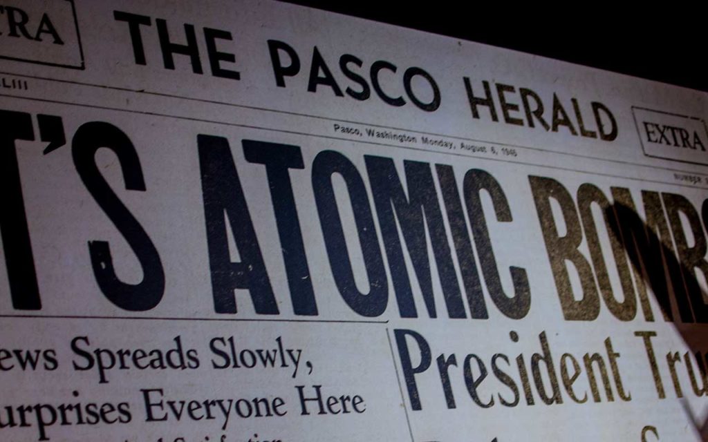
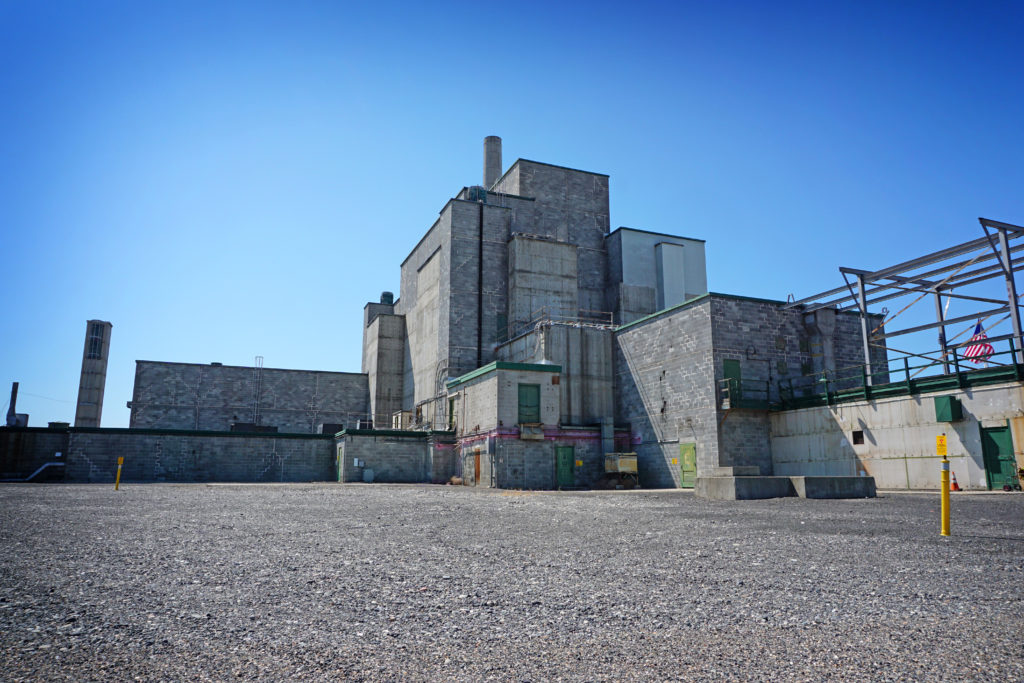
Nine reactors were built on the Hanford Nuclear Reservation in response to various world events. The B Reactor was the first—there was no A Reactor at Hanford—and was built as part of weapons development in World War II and in response to concerns over German development of nuclear capability. Built-in just 13 months, B Reactor was the first full-scale reactor in the world, producing weapons-grade plutonium. Plutonium from the B Reactor was used in the world’s first nuclear explosion, July 16, 1945, at the Alamogordo Bombing and Gunnery Range in New Mexico. B Reactor plutonium was used in the “Fat Man” bomb dropped on Nagasaki, Japan, on August 9, 1945. Fat Man, exploding in a 20 kiloton blast, devastated more than two square miles of the city and caused approximately 45,000 immediate deaths and as many as 150,000 total. Japan sued for peace five days later.

In September of 1949, the Soviet Union successfully tested its own nuclear weapon, well ahead of when American scientists thought it would have the capability. This led to President Truman ordering the expansion of atomic plants, as well as research into the hydrogen bomb—bombs using plutonium from Hanford. This second round of rapid expansion at Hanford lasted through 1955.

The third round of expansion at Hanford began with the election of Dwight Eisenhower as President. President Eisenhower was concerned about the level of military spending and was able to significantly cut spending, especially on conventional forces and equipment. One reason he felt that spending could be cut was through the development of the “massive retaliation” policy, i.e., through the threat of massive nuclear bombing being delivered by the newly developed long-range ballistic missiles.

These reactors are no longer in production and are now being dismantled, the lands and waters remediated.

Presidential Proclamation
Do you know how Presidential Proclamations are passed? The story might start earlier than you think.

In 1988 Senators Dan Evans and Brock Adams introduced Public Law 100-605 to authorize a study of the Hanford Reach for potential consideration as a Federal Wild and Scenic River. The next year, the National Park Service created a task force to study and then draft an environmental impact statement for why the Hanford Reach should be considered for inclusion. Five years after that, the NPS concluded that the Hanford Reach should be included as a recreational river in the National Wild and Scenic Rivers System.

From 1995 to 1997, three polls were conducted, one by the Benton County PUD, one by the Grant County PUD, and another by the Audubon Society. All showed with overwhelming support that Mid-Columbia Basin residents wanted federal action so the last undammed section of the upper Columbia River, the Hanford Reach, would be permanently protected as America’s next Recreational Wild & Scenic River.

Senator Patty Murray first introduced legislation regarding the Hanford Reach in 1995 but it wasn’t until 1997 that the Hanford Reach Wild and Scenic bill was introduced to the 105th Congress. At this time there was a direct conflict between Murray’s bill and Representative Richard Hastings’s HR 181, which would give control of the Hanford Reach to local county governments. So much debate and conflict arose that it required a special hearing before the Committee on Energy and Natural Resources. Approximately 2,000 people showed up for the Congressional Field Hearing in Mattawa, WA (one of the largest events ever held in Mattawa).

Urging federal protection of the Hanford Reach, Senator Murray said that if Congress did not act within a year, she would support administrative action such as an executive order to protect the Hanford Reach.

By 1998, House Joint Memorial 4025, a petition to support Hasting’s bill was introduced into the Washington State Legislature. Washington’s governor at the time, Gary Locke, still supported Murray’s Wild and Scenic Bill with continued federal ownership of the Wahluke Slope. The major flaws seen in Hasting’s bill were the biases toward local control, the appropriate jurisdictions not sufficiently represented, the financial responsibilities not evenly distributed, and actual management of the river was not included.

Letters and phone calls made by local conservation groups and members of the general public were absolutely instrumental in Hasting’s bill dying in the first House committee session. However, only months later, the bill was resurrected in state legislature under a law that allows environmental bills exemption from the committee deadlines. This time the legislature only had one week to pass both the House and Senate and the clock ran out.

On April 6, 1998, American Rivers, a national river conservation organization, named the Columbia River’s Hanford Reach as America’s Most Endangered River. Still, this designation did not protect the Hanford Reach by law.

Later that year, Speaker of the House of Representatives, Newt Gingrich, toured the Hanford Reach. On a separate visit, Katie McGinty, Chair of the President’s Council on Environmental Quality also toured the Hanford Reach. After her visit, McGinty said that President Clinton was absolutely determined that the land surrounding the Hanford Reach would remain in federal control and public ownership. She also mentioned that it was irresponsible to give away several million dollars of public land to private interests at the expense of the environment.

By 1999 the City of Richland and the City of Kennewick Councils had endorsed the Wild & Scenic designation for the Hanford Reach and Senator Murray and Representative Norm Dicks were expected to introduce legislation to designate the Hanford Reach as a National Recreational Wild and Scenic River again. This designation would permanently protect the 51-mile section of the nation’s third-largest river that flows through the northern portion of the U.S. Department of Energy’s Hanford Reservation.

On April 10th, 1999, the Lower Columbia Basin Audubon Society congratulated Secretary of Energy, Bill Richardson, for taking a historic step in protecting the Hanford Reach ecosystem by proposing that all Department of Energy lands on the Wahluke Slope be managed as a National Wildlife Refuge under the stewardship of the U.S. Fish and Wildlife Service (USFWS).

Once again, it was local conservation groups and members of the public that made a difference when the U.S. Dept. of Energy took public comments on its Revised Draft Hanford Remedial Action Environmental Impact Statement and Comprehensive Land Use Plan (HRA EIS); a plan to determine land use classifications for the entire Hanford area for at least the next 50 years. The two options proposed were to designate the vast majority of the Wahluke Slope for preservation as a National Wildlife Refuge or to open up about 2/3 (almost 60,000 acres) of the Slope to agriculture.

In the end, President Clinton sided with the conservation groups and expanded the national wildlife refuge system on the Wahluke Slope of the Hanford Reach. Conservation Chair of the Lower Columbia Basin Audubon Society, Rick Leaumont’s response was, “We congratulate President Clinton, Energy Secretary Richardson, and the U.S. Fish and Wildlife Service for taking a historic step in protecting the Hanford Reach ecosystem by transferring management of the entire Wahluke Slope to the U.S. Fish and Wildlife Service to be managed as a permanent national wildlife refuge. That’s an additional 57,000 acres transferred to the refuge to help protect critical salmon spawning habitat and the Reach itself.”

As you may know by now, President Clinton issued an executive order designating the Hanford Reach a National Monument on June 9, 2000. This designation protected over 196,000 acres of land and the last free-flowing section of the Columbia River.

If you don’t remember the saga spanning nearly twenty years, you might recall in more recent history, President Donald Trump signing an executive order in 2017 directing the Department of Interior to review 27 national monuments, including the Hanford Reach. During a public comment period, the Department of Interior received nearly 1.2 million comments, including nearly 70,000 comments mentioning the Hanford Reach National Monument, many in the form of letters. Suffice to say, the Hanford Reach remains a National Monument.

“Never doubt that a small group of thoughtful, committed citizens can change the world. Indeed, it is the only thing that ever has.” – Margaret Mead

USFWS
The Hanford Reach National Monument is managed as part of the Mid-Columbia River National Wildlife Refuge Complex, which also provides management and support for seven wildlife refuges in the region.

Refuges are grouped into a complex structure because they occur in a similar ecological region, specific habitat type, and have a related purpose or management needs. Typically, a project leader or Complex manager is responsible for operations at specific refuges while overseeing the general management of all refuges within the Complex. Supporting staff, composed of administrative, law enforcement, biological, fire, visitor services, and maintenance professionals, are centrally located and support all refuges within the complex.

There are two main habitats in the Hanford Reach National Monument: desert and river, shrub-steppe and riparian.

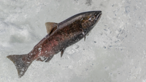
Islands, riffles, gravel bars, oxbow ponds, and backwater sloughs provide support to forty-three species of fish. Large numbers of Fall Chinook salmon spawn in the Hanford Reach. Federally threatened species such as the Spring Chinook and steelhead use the Reach for migration purposes.

The Hanford Reach provides motorized and non-motorized boating opportunities. Anglers can pursue salmon, steelhead, white sturgeon, largemouth bass, walleye, and many other sportfish. Kayak tours are excellent ways to see the river, experience its history, and catch a glimpse of deer, pelicans, coyotes, bald and golden eagles, egrets, herons, and waterfowl of all descriptions.

The dry, desert region is home to forty-two mammal species. Mice are the most abundant and include the deer mouse, western harvest mouse, northern grasshopper mouse. Other mammals that inhabit this refuge include coyotes, skunks, beavers, mule deer, bobcats, river otters, minks, cougars, and badgers.

The refuge is famous for the elk located on the Arid Lands Ecology Area (ALE). Herd numbers vary by time of year with 150 seen during the spring/summer and 350 to 375 during the fall. The elk population reaches its peak in the winter with an average of 670. During the mid-19th century, first-hand accounts mentioned the disappearance of the species. Rocky Mountain elk were reintroduced into the region during the 1930s, as well as a natural recolonization event from the nearby Cascade Mountains during the difficult 1978 winter. Today, hunters can pursue trophy mule deer and elk after obtaining a permit. Information on permits can be found on the USFWS website.

Still, there is abundant wildlife that provides year-round opportunities for photography and wildlife observation. Spring brings good wildflower shows. Old military and service roads provide miles of hiking opportunities, and the more adventurous can head off cross-country on foot. The Monument is a land of extremes—heat and cold, water and desert, ancient and modern. While not an unduly dangerous landscape, caution needs to be taken when venturing out into it.

Lastly, it must also be noted that a large part of the Monument is closed to the general public to preserve wildlife habitats as well as cultural management. Activities can be limited or restricted depending on the season too, so it is best to check before visiting.

US Fish & Wildlife Service